여강길 11코스

여주여강길 앱과 겹쳐 올라가 설명 만 올림 여강길 앱에서 완주 인증때문에 올리면 2개가 같이 올라가서 내용생략

Hiking/Backpacking

역방향 권함 스틱필요 
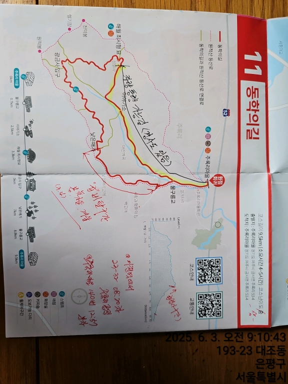
교통편 : 출발 :이천역에서 23-32번 08:20분차 주록리 종점 1시간10분정도 귀가:주록리 마을버스정류장 12:57분차 140번 여주역행 세종대왕릉역 하차 50분정도
Yeoju-si, Gyeonggi, South Korea
baeheehong photo
time : Jun 2, 2025 9:30 AM
duration : 2h 57m 18s
distance : 9.5 km
total_ascent : 464 m
highest_point : 462 m
avg_speed : 3.4 km/h
user_id : baeheehong
user_firstname : 홍배희
user_lastname : 홍
여주여강길 앱과 겹쳐 올라가 설명 만 올림 여강길 앱에서 완주 인증때문에 올리면 2개가 같이 올라가서 내용생략
Info
Name
 
About Me
Media Contents
  •  
  • -
  •  
  • -
  •  
  • -
  •  
  • -
Most Frequent Activity
1.
-
2.
-
3.
-
Widget
Copy the widget source code below and paste into your blog template.
 
( / )
  No more trips to show
 
No more trips to show
baeheehong's Collections
 
Sorry, the collection could not be found.
Bookmarked Collections
 
Sorry, the collection could not be found.
 
(0)
  There is no data
Blocked Users(0)
  There is no data
Ramblr passports
  Share

  Grab the URL link to the passport.

0 like(s)
 
(0 / 0)
Badges (0)
These are the badges you have acquired. Click to see the details.
     
     
    These are the badges you have acquired. Click to see the details.
    Badges acquired
      Full Screen
     
      Google Map
      Naver Map
    Statistics
    • Total
      Trips
      -
    • Total
      Distance
      -
    • Total
      Duration
      -
    • Highest
      Point
      -
    • Total
      Ascent
      -
    • Average
      Speed
      -
    Most Frequent Activity
    Click on the stat type above to see its graph.
  • First Certification Date :
  •  
    Following
      Follow
    Unfollow
  • 0
     
    There is no badge.
  • Draft
    Private
    Secret
     
    -
      Edit
      Delete
    Are you sure you want to delete this trip?
    YES, delete
    NO, cancel
    Add to Collection
     
     
    Create a Collection Edit Collection
     
    Name
     
    Description
     
    Visibility Setting
     
    Trip Sorting by
     
    Cover Picture