Whatcom County, Washington, United States
time : Jul 27, 2019 12:49 PM
duration : 23h 34m 30s
distance : 19.6 mi
total_ascent : 5135 ft
highest_point : 7044 ft
avg_speed : 1.4 mi/h
user_id : littlesportsman
user_firstname : Lawrence
user_lastname : Kuracina
2 day backpack to a recently semi-restored lookout. There is a creek crossing at the beginning and a lot of navigating a nearly disappeared trail.
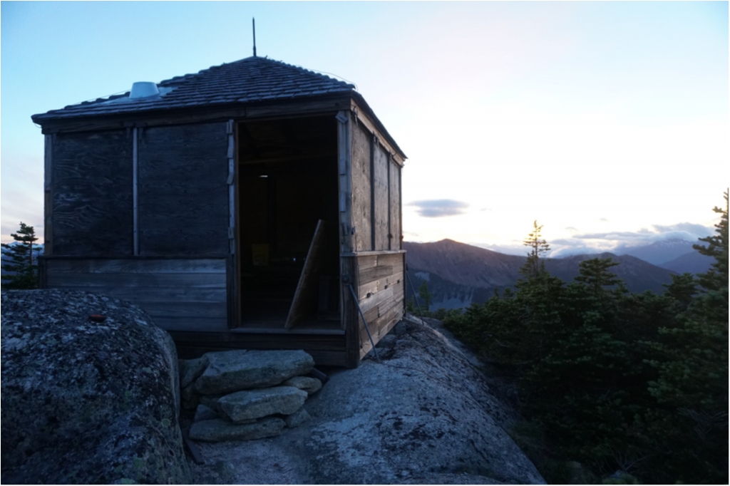
This L-5 cab, built in 1933, was probably abandoned in 1941. It is the last L-5 cab known to exist. Some preservation work took place in 2002.
I saw no body for two days while I was on the trail. The scenery was incredible!
Take the East Creek trail from highway 20 in the North Cascades between Diablo & Mazama).
I didn't take rain pants and as the trail is over-grown the vegetation was all wet with dew in the morning and my hike out I got soaked from the waist down. But the weather was nice so it was okay.
The first question is how to get across Granite Creek as it is typically rushing and the bridge washed-out years ago. It seems that every year there are different fallen trees that are used as a make-shift bridge. This year that tree is a little up-stream. Follow the path down to the bridge, keep going through an area with campsites then the trail leads out onto the rocks. Follow that until you see a path down through the brush and you'll find the bridge as in the photo below. It's a nice easy crossing.
As you can see from the profile: Mebee starts steep and then levels out for a couple miles as one navigates through some meadows and cross-crosses East Creek a couple of times. It's only this middle section that can be confusing.
The trail then gets steep again as it climbs up to Mebee Pass. The final section to the Lookout is a scramble (maybe T2). Just follow the ridgeline up. You won't see the lookout until almost upon it. In the middle section are pink ribbons to follow. I would say that this middle section starts about 4.5 miles in, just a little past the remnants after the trail splits (trail goes up to an old mine). at the trail split there was a sign on the ground that said "Granite Creek 4 miles, Mebee Pass 4 miles". It's more like 6 miles to Mebee Pass Lookout from there.
The middle section end when you cross East Creek two more times (as you cross once earlier before the trail split). There were log crossings at each spot.
NOTE1: Do not follow the pink ribbons through the slide alder. Follow the slide down-hill for say 100 ft and then there is a trail through the field.
NOTE2: There is a water source around 6100 ft (last water before the summit).
I used a 1 litre bottle and kept pumping/filtering water when I was getting low (I was a little concerned around 5500ft if I was going to find more water but it was there).
NOTE3: The trail in this middle section is a little different from the trail on the map. I followed the ribbons (and a gps track).
References:
Friends of Mebee Pass:
http://www.stephabegg.com/home/tripreports/washington/northcascades/mebee
Restoration project:
https://vimeo.com/75817461
Trip data 91/18 with some excellent guide notes:
http://www.davecoate.com/mountain-navigation/index.html
Some of these notes include the following, but please refer back to the original for a link of notes to map section.
NOTE-A (as Note1 above): Going south from the Mine there is a wash out of the trail. We went slightly down this and spotted a bright pink ribbon in the slide alder on the opposite side. Upon reaching this and peering in, we spotted another ribbon and another. Do not be fooled by these! When we reached the far side of this thicket of slide alder, the ribbons stopped and we were in the wrong place! Instead descend the washout serveral hundred feet and find the trail just as it is marked on this map (dashed line). Follow faded, almost white, ribbons and cairns on the way down. On our return trip, we found that it is not necessary to bush whack through the slide alder. Just don't do it!
NOTE-B: When the trail emerges from the forest, the trail makes its way down to East Creek through a meadow. It crosses the creek for a second time. (The first was a mile before the mine on a log near some nice wooded campsites) This crossing is a bit farther south than where the dashed line would indicate. When we tried it, it was necessary to take off our boots and wade. On the opposite bank immediately climb into the meadow and follow the trail to the south again. The pink ribbons are mostly useful in this section before the crossing, but there seemed to be at least one that was too high near the creek crossing.
- I had a log here to cross and the water level was low (see photo below)
NOTE-C: In this section the trail is in a very different place than as it is marked (dashed line). The trail crosses the creek a third time on a log far before the dashed line would indicate and the pink ribbons are trustworthy. In this section the trail gets easier to follow and clearer.